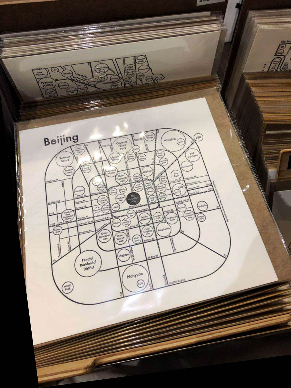
北京市思维导图 Beijing Mind Map for Archie's Press
与纽约地图与压印艺术家亚历山大 · 阿尔奇 · 阿尔尚博合作项目/In collaboration with Archie’s Press凸版印刷;20 x 20 cm/letterpress print; 8 x 8 inch
2018年春,纽约,纽约州/Spring 2018, New York, NY
April 17th, 2018, 温斯特-萨勒姆,北卡罗来纳州/Winston-Salem, NC
from: 韩立/Li Han <thelostshrimpball@gmail.com>
to: 阿尔奇/Archie <archie@archiespress.com>
date: Tue, Apr 17, 2018 at 10:33 AM
subject: 关于合作项目/About the Collaboration Project
嗨,阿尔奇:
我想知道你是否还想合作上海和北京市思维导图设计。请麻烦告知。
感谢,
韩立
Hi Archie:
I wanna have a quick check if you still wanna collaborate the Mind Maps of Shanghai and Beijing. Please feel free to let me know.
Many thanks,
Li
April 17th, 2018, 温斯特-萨勒姆,北卡罗来纳州/Winston-Salem, NC
from: 阿尔奇/Archie <archie@archiespress.com>
to: 韩立/Li Han <thelostshrimpball@gmail.com>
date: Tue, Apr 17, 2018 at 10:44 AM
subject: 回复:关于合作项目/RE: About the Collaboration Project
嗨,韩立!
十分抱歉我回复晚了。我最近很忙所以忘了做新地图这件事了!
现在我们可以开始了。那就让我们先从一个开始然后看看会怎样发展。
你最想从哪个城市开始?地图设计主要就是关于对城市地理的熟悉度。
我把设计说明和 “项目介绍” 添加在附件了。你可以翻看一下。
如果有什么问题随时联系!
再次感谢!
阿尔奇
Hi Li!
I’m so sorry for my delay. I got so busy and I lost track of making new maps!
But now is a good time for me to start on some new things. So yes! Let’s try one of them first and see how it goes.
Which one do you feel the most confident doing? It is ALL about knowing a lot about the geography of the place.
I’m attaching the style guide and a little “intro deck” for you to flip through.
Let me know if you have any questions!
Thanks again!
Archie
2个附件/2 Attachments
April 18th, 2018, 温斯特-萨勒姆,北卡罗来纳州/Winston-Salem, NC
from: 韩立/Li Han <thelostshrimpball@gmail.com>
to: 阿尔奇/Archie <archie@archiespress.com>
date: Tue, Apr 18, 2018 at 11:36 AM
subject: 回复:关于合作项目/Re: About the Collaboration Project
嗨,阿尔奇:
不要在意这些细节!没事!我觉得我们可以从北京地图开始因为我来自北京。你觉得如何?
祝好,
韩立
Hi Archie:
No worries at all! Everything sounds perfect! I think we can start with the Beijing map since I'm originally from Beijing. Is it OK for you?
All the best,
Li
April 18th, 2018, Winston-Salem, NC
from: 阿尔奇/Archie <archie@archiespress.com>
to: 韩立/Li Han <thelostshrimpball@gmail.com>
date: Tue, Apr 18, 2018 at 5:12 PM
subject: 回复:关于合作项目/RE: About the Collaboration Project
嗨,韩立,
那我们就从北京开始。
我是这么想的,但是你可以纠正我要是我理解错了的话,毕竟我完全不了解北京。
我们肯定不可能把整个北京市都画出来。根据经验来说把整个城市都记录下来并没有太大意义因为只有很少数人才对整个城市有完整的了解。所以只选择中心城区更加合理。
尤其是对北京来说,它有环路系统可以形成一个很好看的构成。看一下附件的.ai文件。你觉得同心圆可以么?大多数地图用的是圆角矩形。你觉得哪个方案感觉更像北京?我喜欢方案2,但是我并不了解北京。我们应该再扩大一些城区范围吗?还是缩小一些?你肯定能做出更好的判断!
试想人们会如何在城市里生活:人们更常坐地铁吗?地铁站会更好地界定各个区块吗?如果是这样的话,那我们是不是应该用地铁线路作为地图的骨架呢?
就像我之前说的,如果这并不是很有北京的感觉的话就告诉我。你也可以尝试别的方案。
我喜欢从决定地图的构成开始入手,然后再往上添加更多内容。因为一旦细节加上去就很难再往回改了。
谢谢你!
阿尔奇
Hi Li,
Great, Beijing it is.
Here’s what I’m thinking, but you can tell me I’m wrong since I don’t know anything about Beijing:
There is absolutely no way we can map the whole thing for a couple of reasons: I’ve learned that trying to describe the entire city is pointless since very few people have knowledge of the whole city. It makes more sense to choose the more central areas.
Especially for Beijing, there is a ring road system that will make a beautiful composition. See attached .ai file. Do you think concentric circles would work? Most maps have them more like squares. Which of these do you think feels most like “Beijing”? I like #2, but I don’t know anything. Should we zoom out? Zoom in? Only you can answer these questions!
Think about how people use the city: do most people take the train? Do the stations define the neighborhoods? If that’s true, should we use the subways as the skeleton?
Like I said, please tell me if this doesn’t feel like Beijing at all, and please propose what you think would work.
I like to start the process by deciding this composition before we put any content in, mostly because it’s very difficult to work backwards.
Thanks Li!
Archie

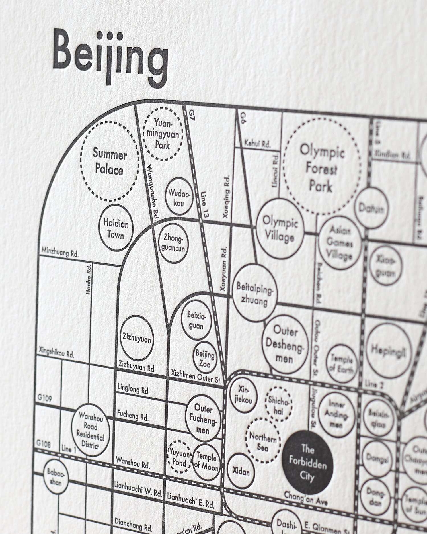
根据阿尔奇对北京市的第一印象,环路系统(二环路,三环路,四环路和S50/五环路)似乎很吸引他。并且他设计了如下四个网格系统来开始设计。
Based on Archie’s impression of the city, the ring road system (2nd Ring Rd., 3rd Ring Rd., and 4th Ring Rd. and S50/5th Ring Rd.) seems to be appealing and he designed these four grid systems to get us started.


April 19th, 2018, 温斯特-萨勒姆,北卡罗来纳州/Raleigh, NC
from: 韩立/Li Han <thelostshrimpball@gmail.com>
to: 阿尔奇/Archie <archie@archiespress.com>
date: Tue, Apr 19, 2018 at 10:42 AM
subject: 回复:关于合作项目/Re: About the Collaboration Project
嘿,阿尔奇:
我现在正在从北卡罗莱纳回纽约的路上。从明天开始我就能专注在我们的地图和合同上了。等我做出什么东西以后我就会跟你联系。
没错!北京的环路系统非常有名而且我觉得我们只做五环路以内的范围非常明智。五环以外基本上就没有什么东西了。我已经看了你发给我的Illustrator文件。同心圆感觉并不是很北京。北京著名的就是方方正正的四九城。而且从地图上你可以看到在北京的中心区是紫禁城。它是长方形的而且北京的城市规划就是围绕着它来的。我会在方案二或方案三圆角矩形的基础上做一些调整然后尽快联系你。
祝好,
韩立
Hey Archie:
So, I'm on my way back to NYC from North Carolina now. I'll be actively working on the map and the contract tomorrow and let you know if I figure something out.
Yes! Beijing is famous for its ring road system and I think cutting off from the 5th Ring Road is very smart. There's literally nothing much outside 5th. I have already gone through the Illustrator file you sent me. The concentric circles are not very Beijing-ish. Beijing is famous for being square-ish and you can see from the map that at the hub of the city there is the Forbidden City. It's a rectangle and the development of the city comes from it. I'll make a little change based on the 2nd or 3rd page—the round-cornered rectangles and get back to you asap.
All the best,
Li
我做了些北京市的相关调研:
I did some more research on the urban design of my hometown:
环路系统骨架/Ring Road System Skeleton:


在道路比例和命名系统上,北京市最具代表性的一点就是二环路的下半部分外城比上半部分内城宽。就因为这点使北京市的环路规划独一无二,所以我希望在我的设计中保留这点。五环路是一条高速公路。其实它的官方命名是 “S50” 但老百姓都约定俗成地叫 “五环路”。为了使我的设计在版式、民俗和系统性上更接地气,我决定把 “S50” 和 “五环路”标注在一起。
For the proportion and the naming system, one of the most representative characters of Beijing’s is that the bottom part, the Outer City within the 2nd Ring Road is wider than its top part, the Inner City. This feature differentiates Beijing from any other cities using the ring road system all over the globe. Therefore, I prefer to keep it in the design. The 5th Ring Rd. is an expressway. Actually, its official English naming is “S50” but Beijing residents somehow still call it the “5th Ring Road.” Therefore, to make the design consistent typographically, epidemically, and systematically, I decided to double name it “S50/5th Ring Rd.”
辅助放射状高速公路网/Additional Radial Expressways:
在我的设计中选取了环路系统作为第一层主要信息,第二层辅助信息我决定使用线状高速公路。两层信息在一起形成了网状放射结构。官方命名由道路的起终点和数字标号共同组成(“G” 为国道;“S” 为省道),然而我们还有更加通俗易懂的另一种命名方式。下面罗列的信息就是我通过调研找到的相关资料。在现阶段,到底该使用哪种命名还暂时留个问号。
环路系统:二环路、三环路、四环路、五环路/S50
长安街:对二环内西长安街和东长安街约定俗成的统称
G102:102国道,1297 km,始于东三环与东四环之间,连接北京与哈尔滨
G103:103国道,150 km(最短的国道),始于东二环与东三环之间,连接北京与塘沽
G104:104国道,2390 km,始于南二环,北京段也作南苑路,连接北京与福州
G105:105国道,2717 km,始于南五环,连接北京与珠海
G107:107国道,2698 km,始于西南二环,连接北京与深圳
G108:108国道,3356 km,始于西二环,连接北京与昆明,北京段也作京原路
G109:109国道,3901 km,始于西二环,连接北京与拉萨
G110:110国道,1100 km,始于西二环,连接北京与银川
G111:111国道(部分为S12—机场高速),2123 km,始于东北二环,连接北京与黑龙江省
G1:G1国道/京哈高速(部分为京沈高速),1251 km,始于东四环
G2:G2国道/京沪高速(部分为S40—京津唐高速),1261.99 km,始于东南三环
G4:G4国道/京港澳高速(部分为京石高速),2272.65 km,始于西三环
G6:G6国道/京藏高速(前八达岭高速),69.98 km,始于北三环马甸立交桥
其曾用名 “八达岭高速” 源于万里长城八达岭段
G7:G7国道/京乌高速,2540 km,始于北四环北五环之间
G45:G45国道/大广高速(部分为京承和京开高速),3550 km,现阶段于东北三环与西南三环之间断开
S12:机场高速(111国道的一部分),20 km,连接东北三环三元桥和北京首都机场
S40:京津唐高速(G2国道—京沪高速的一部分),143 km,始于东南二环
As ring road system being the primary layer, a secondary layer is composed of linear expressways, which forms a radial web. The naming is compounded by its connection (The letters are the initials of the phonetic spelling mimicking the Chinese pronunciation. “G” represents intercountry and “S” stands for interprovince.) and numbering. In Chinese, they are both double named. Below is the result of what I have researched and it’s gonna be remaining as an open question how to name them on the map temporarily.
Ring Road System—2nd Ring Rd., 3rd Ring Rd., 4th Ring Rd., and S50/5th Ring Rd.
Chang’an Ave.—an imaginative conclusive name of W. and E. Chang’an Ave. within the range of 2nd Ring Rd.
G102—China National Highway 102, 806 mi
starts from in between E. 3rd and 4th Ring Rds; connects Beijing to Harbin
G103—China National Highway 103, 90 mi (the shortest China National Highway)
starts from in between E. 2nd and 3rd Ring Rds; connects Beijing to Tanggu
G104—China National Highway 104, 1,490 mi
starts from S. 2nd Ring Rd.; connects Beijing to Fuzhou, whose Beijing section is known as Nanyuan Rd.
G105—China National Highway 105, 1,688 mi
starts from S. 5th Ring Rd.; connects Beijing to Zhuhai
G107—China National Highway 107, 1,676 mi
starts from SW. 2nd Ring Rd.; connects Beijing to Shenzhen
G108—China National Highway 108, 2.085 mi
starts from W. 2nd Ring Rd.; connects Beijing to Kunming, whose Beijing section is known as Jingyuan Rd.
G109—China National Highway 109, 2,424 mi
starts from W. 2nd Ring Rd.; connects Beijing to Lhasa
G110—China National Highway 110, 700 mi
starts from N. 4th Ring Rd., connects Beijing to Yinchuan
G111—China National Highway 111 (Partially S12—Airport Expressway), 1,319 mi
starts from NE. 2nd Ring Rd.; connects Beijing to Heilongjiang Province
G1—Beijing–Harbin Expressway (Partially Jingshen Expressway), 777 mi
starts from E. 4th Ring Rd.
G2—Beijing–Shanghai Expressway/Jinghu Expressway (Partially S40—Jingjintang Expressway), 784.16 mi
starts from SE. 3rd Ring Rd.
G4—Beijing–Hong Kong–Macau Expressway/Jinggang’ao Expressway (Partially Jingshi Expressway), 1,412.16 mi
starts from W. 3rd Ring Rd.
G6—Beijing–Lhasa Expressway (Former Badaling Expressway), 43.48 mi
starts north of Madian Overpass on N. 3rd Ring Rd.
Its former name “Badaling Expressway” was originated from the Badaling stretch of the Great Wall.
G7—Beijing–Ürümqi Expressway, 1,580 mi
starts from in between N. 4th and 5th Ring Rds
G45—Daqing–Guangzhou Expressway (Partially Jingcheng and Jingkai Expressway), 2,210 mi
3550 km; temporarily ends at NE. 3rd Ring Rd. and restart from SW. 3rd Ring Rd.
S12—Airport Expressway (Part of G111—China National Highway 111), under 12 mi
under 20 km; Links Sanyuanqiao on the NE. 3rd Ring Road to Beijing Airport
S40—Jingjintang Expressway (Part of G2—Beijing-Shanghai Expressway), 89 mi
143 km; starts from SE. 2nd Ring Rd.
May 2nd, 2018, 纽约,纽约州/New York, NY
from: 韩立/Li Han <thelostshrimpball@gmail.com>
to: 阿尔奇/Archie <archie@archiespress.com>
date: Wed, May 2, 2018 at 11:14 PM
subject: 回复:关于合作项目/Re: About the Collaboration Project
嗨,阿尔奇:
不好意思回复晚了。最近在我的生活里有一些重大的变化。现在我终于重新振作可以专心做北京地图了。在你的环路系统的基础上我做了些修改。详见附件的方案5和方案6。我个人更喜欢方案5因为北京的城市规划就是四方形和垂直交叉的道路网。但我觉得方案6还挺独特的。没准用圆形的设计来做北京也会有意想不到的结果。
我有个道路命名的问题想跟你讨论一下:很多高速路有两个名字。在说中文的时候我们说一种而说英文的时候我们说另一种且两者没有任何联系。比如:我在北京的家就挨着 “G6”,G6是这条高速路的官方英文命名。但是说中文的时候我们通常说 “京藏高速”。我尝试了把两种命名全都标注在地图上但是那样的话字就太多了。我觉得是不是可以看受众群体来决定用哪种命名?所以 “G6” 是不是更好一些?你觉得呢?P.S. 唯一一个我决定用双重命名的是 “S50/五环路”。我查了些资料。“S50” 是它的官方命名但同时它也是一条在环路系统上向外扩张的环路而且北京人都俗称它五环路。所以我觉得在这条路上双重命名比较合理。
说到往下继续深入的话,我们可以在道路网上加更多1 pt的主干道。因为北京的道路网本身非常复杂,所以我觉得精选出最具代表意义的路效果会比较好。我还想在地图上囊括几条主要的地铁线路,这样可以增强北京的感觉。现在北京有22条已投入使用的地铁线。但在北京的轨道运输系统还在发展的时候,很长一段时间就只有1号线、2号线、5号线、10号线、13号线和机场快轨。北京市轨道交通的发展有几个重要阶段,但我觉得如果把目前有的所有22条地铁线路都画出来并不是很可取。你怎么看?还有你觉得还有什么主要的子分类我们可以在加入更多像地区、公园和地标这样的细节信息之前加到网格上?
你有什么想法都可以跟我说。期待继续往下深入。哈哈~
祝好,
韩立
Hi Archie:
Sorry about this delay. There was something major happened in my life and I finally got myself together and I'm able to work on the Beijing map full-time. I finished some rearrangements on my side based on the grid systems. Here I attached the file to this email. There are #5 and #6. I personally prefer #5 because Beijing is famous for it rectangular urban design and perpendicular grid system. But I think #6 is also very interesting and appealing and there might be potential for utilizing unique circular design to represent the city.
I also have a question about the naming of the roads that I wanna discuss with you: So the expressways are double named, which means, in Chinese, we usually say one name and in English, we say another and both of them have no linguistic connection at all. For instance: My home in Beijing is right by "G6," which is the official naming of the expressway in English. But in Chinese, we say "Beijing–Lhasa Expressway." I tried naming both on the map but I think it's over text-heavy. I guess it could be determined by the targeted customer? So “G6” might be better? What do you think? P.S. The only one I remained double named on the file is "S50/5th Ring Rd." I did some research and its official name is "S50" but it is also a ring road following the same ring road system and all Beijingers are using it. So I think double naming this one is reasonable.
For future steps, we can add some more 1pt roads in the grid system for sure, which are the most famous and important ones. Since the grid is literally super complicated, I think applying selected ones would work better. I also have a thought of including some of the subways routes. That would be creating a strong impression of Beijing. Right now, there are 22 subways lines in use. But for a very long time in Beijing's transporting system development, there were only Beijing Subway Line 1, 2, 5, 10, 13, and Airport Express. There are several stages of its developing, but I personally don't think including all the up-to-date trains would be the best way. What do you think and what do you think would be some potential main subcategories of the city elements we could add to the grid we are trying to create before adding more detailed information such as neighborhoods, parks/gardens, landmarks, etc.?
Please feel free to let me know anything and I am looking forward to moving forward. Lol
All the best,
Li
在做了上述调研后,根据阿尔奇几何与极简的设计要求,我把网格的角度进行了整理、归纳和简化最终做出了如下的两个方案:
After the aformentioned research, following Archie’s design regulation on the maps to make them geomatric and mimimal, here I straightened and angled up the ring road system and additional radial expressways and designed the folowing two approaches:

May 3rd, 2018, 纽约,纽约州/New York, NY
from: 阿尔奇/Archie <archie@archiespress.com>
to: 韩立/Li Han <thelostshrimpball@gmail.com>
date: Thu, May 3, 2018 at 10:45 AM
subject: 回复:关于合作项目/RE: About the Collaboration Project
嗨,韩立!
感谢你及时的反馈。晚点没事。很高兴你重新振作起来了。
我觉得方案6很好!这个骨架很完美。你可以继续往上添加细节了。
关于道路命名:我觉得我们有足够的空间在地图把很长的中文名和英文都写上。我觉得把英文放到五环外很不错,这样你就可以把中文名放到四五环中间了。但如果中文路名被地区名挡住了的话,那就是个问题了。你怎么看?
我觉得同一条路的笔划粗细度应该保持一致(109国道、102国道、G7国道等等)。我不喜欢从2pt转换到1pt的效果。
还有,二环路南半部变宽了这点很重要吗?如果不重要的话,把它删掉。
好了!有什么问题的话及时沟通。
Hi Li!
Thanks so much for the quick response. No problem about the delay and I am glad you are recovering.
I think #6 looks great! It’s a perfect skeleton and you can start adding things to it.
Road names: I think there is plenty of space to write the longer Chinese name as well as the English name. I like the English on the outside, and then you can add the Chinese name between 4th and 5th ring roads. If the Chinese name is gets blocked by the neighborhood name, that might be a problem. What do you think?
I think you can keep the stroke consistent throughout the entire road (G109, G102, G7 etc). I don’t like how it looks when it switches from 2pt to 1pt.
Also, is it very important that the 2nd ring road has those corners intruding on the shape on the south end? If not, please remove them.
OK! Let me know if you have any questions.
May 3rd, 2018, 纽约,纽约州/New York, NY
from: 韩立/Li Han <thelostshrimpball@gmail.com>
to: 阿尔奇/Archie <archie@archiespress.com>
date: Thu, May 3, 2018 at 11:45 AM
subject: 回复:关于合作项目/Re: About the Collaboration Project
嗨,阿尔奇:
我可以在方案5-1和方案6-2上做一些快速的尝试,看看把长中文命名放上去效果如何。如果我们在地图上放更多的圆形的话,我确实觉得有些会冒着被挡住的风险。要真是这样的话,我们可以用回方案5和方案6。因为英文命名是官方命名,更通用也会使地图看起来更简洁。
有些高速路我用了两种比划宽度是因为这些高速路有特定的起始点。当进入到中心城区的时候很多就不再是高速路了。你觉不觉得如果加上更多1 pt的道路网之后会使这种突兀的转换有所缓和?我觉得它们到时候就会融入网格了。还是说你还是希望它们都保持一致都用2 pt的宽度?我今天晚点就能发给你我加上更多1 pt网格的进度。你可以到时候再看然后我们再决定该如何修改?
还有针对二环路的那个问题,没错!这就是它的形状,下半部比上半部宽。我最开始也试过用圆角矩形和正圆形让整个地图看起来更几何做到尽可能极简(我一直记着这点呢。呵呵)。但是这样就显得不是很北京了。我们北京人经常开玩笑说二环路的形状像个 “凸” 字。所以我个人还是认为应该保留这个形状不改。你觉得呢?
提问:在做图的时候铁路有什么要求?在你之前发的设计要求的文件里你没写。我看之前你设计的巴黎和芝加哥地图里都有铁路系统。是不是就是把白色的虚线摞在黑色的实线上面?宽度是多少?告诉我之后我就可以加上了。
祝好,
韩立
Hi Archie:
I can make a quick easy try of #5-1 and #6-2 to put longer Chinese names onto the maps and we'll see what's gonna be happening. If we put more circles on the map, I do think that some of them might take the risk of being blocked, then we can just use the original #5 and #6 since the English naming is official and more universal and it'll make the map cleaner.
The reason why I made some of the expressways in two stroke weights is because expressways start from specific points. A lot of them are not expressways anymore when they enter the hub of the city. Do you think adding more 1pt grid system will help ease the change since some of them will merge into the grid? Or do you still prefer to make them consistent all in 2pt? I can send you the file adding more grid in 1pt later today and you can see how it turns out and we can make our decision on this together?
And for the 2nd ring road, yes, it's just its shape having those corners intruding on the south end. I did try a perfect round-cornered rectangle and circle at the very beginning to make the entire map geometrically clean and as minimal as possible, (I promise that I am keeping this in my mind. Lol) but it makes the impression of the city of Beijing weaker. We Beijingers always made this joke of using the Chinese character "凸" to represent Beijing's 2nd Ring Road and the impression of the city. So I personally prefer to keep the shape instead of making it simpler. What's your opinion about this?
Quick question: What is the regulation of railways? I didn't find it in the regulation file you sent to me earlier. I saw that your former design of Chicago and Paris have the railway system in it. Is it double stroked path overlapping on top of each other that one is black and the other one white dash? What are the thickness? Please let me know, and then I can add it.
Best,
Li
May 3rd, 2018, 纽约,纽约市/New York, NY
from: 阿尔奇/Archie <archie@archiespress.com>
to: 韩立/Li Han <thelostshrimpball@gmail.com>
date: Thu, May 3, 2018 at 12:10 PM
subject: 回复:关于合作项目/RE: About the Collaboration Project
嗨,韩立!
这些思路都不错。
我其实对笔触粗细并没有什么太大感觉,你可以维持现状。
我觉得这样来看二环路的形状很合理。解释得很在理。
那些 “铁路” 通常就是高速公路。你可以这样做:在视图面板中选择你想要使用的笔刷。点击下方的 “创建新笔刷” 之后你会得到两个 黑色的笔触。把上方的笔触(1 pt)设置为白色虚线(3 pt的长度和3 pt的空隙)然后把下方的笔触设置为3 pt。如果你觉得不合适的话,我们可以继续讨论。
感谢你回复得这么快!
Hi Li!
Those are all great thoughts.
I actually don’t have super strong feelings about the stroke weight, you can leave that for now.
I think the 2nd Ring Road makes sense. Great thinking.
Those “railroads” are usually highways. To make them: Go to your appearance panel and select the stroke you want to use. Click “new stroke” on the bottom. Now you have two black strokes. Make the stroke on top white (1pt) with dashed lines (3p. dash with 3 pt. gap). Make the stroke on the bottom 3pt. If that doesn’t make sense, let me know.
Thank you for the quick response!!
在这一轮 “接力赛” 之后,我开始了北京轨道交通的相关调研。我觉得地铁线路作为次级网格系统可以形成很好的第二层信息,同时还能加强北京印象。
After this round of “tennis playing,” I started to do some research on the Beijing subway system. I think it could be a great second layer being a “sub-grid system” and it could reinforce the impression of the city.


北京地铁是服务于北京城区和郊区市民的的快速轨道交通网。目前北京市拥有共计22条地铁线路、370座车站,轨道运营长度长达608.2千米位居全球第二(1. 上海;2. 北京;3. 伦敦;4. 纽约市;5. 首尔)。但如果全部线路都在地图上绘制出来的话就会显得冗余。所以我决定只画出精选过的几条线路。
Beijing Subway is a rapid transit rail network that serves the urban and suburban districts of Beijing municipality. For now, there are 22 subway trains with 370 stops and a total length 377.9 mi ranking second all over the globe (1. Shanghai; 2. Beijing; 3. London; 4. New York City; 5. Seoul). But if they are all being shown on the map design, it’s definitely gonna be overwhelming. So I made the decision to only include selected subway trains.
筛选后的北京地铁线路图/Selested Beijing subways trains:
1号线—长安街下的一条东西向直线线路,又名 “复八” 线,曾用名 “一线地铁”;23座车站;30.3 km
2号线—明城墙根下的内环线路,又名 “环线地铁”;18座车站;23.1 km
5号线—在东部的一条南北向直线线路;23座车站;27.6 km
10号线—部分在三环下或三环内的外环地铁,北段在明城墙遗址下;45座车站;57.1 km
13号线—跨越北方近郊的U形线路;16座车站;40.5 km
机场快轨—连接城区与北京首都机场;4座车站;28.1 km
八通线—1号线向东南近郊的延长线路;13座车站;18.9 km
这七条筛选出的地铁线路也是北京市轨道交通建设中最早的七条线路:
2000年06月28日—1号线与2号线;
2003年01月28日—1号线、2号线与13号线;
2003年12月27日—1号线、2号线、13号线与八通线;
2003年12月27日—1号线、2号线、13号线与八通线;
2007年10月07日—1号线、2号线、13号线、八通线与5号线;
2008年07月19日—1号线、2号线、13号线、八通线、5号线、10号线与机场快轨。
Line 1—a straight east-west line underneath Chang'an Avenue
other named “Fuba Train” and former “Horizontal Train;” 23 stops; 18.8 mi
Line 2—the inner rectangular loop line traces the Ming-era inner city wall
other named “Loop Train;” 18 stops; 14.35 mi
Line 5—a straight north-south line to the east of the city center
23 stops; 17.15 mi
Line 10—the outer loop line runs underneath or beyond 3rd Ring Road; traces Beijing's Yuan-era city wall in the north
45 stops; 35.5 mi
Line 13—across north suburbs of the city
16 stops; 25.2 mi
Airport Express—connects the Beijing Capital International Airport
4 stops; 17.5 mi
Batong Train—extends Line 1 eastward to SE. suburbs
13 stops; 11.7 mi
These 7 selected trains also the earliest 7 trains constructed in the city among all:
June 28th, 2000—Line 1 and Line 2;
January 28, 2003—Line 1, Line 2n, and Line 13;
December 27th, 2003—Line 1, Line 2, Line 13, and Batong Line;
October 7th, 2007—Line 1, Line 2, Line 13, Batong Line, and Line 5;
July 19th, 2008—Line 1, Line 2, Line 13, Batong Line, Line 5, Line 10, and Airport Express.
May 3rd, 2018, 纽约,纽约州/New York, NY
from: 韩立/Li Han <thelostshrimpball@gmail.com>
to: 阿尔奇/Archie <archie@archiespress.com>
date: Thu, May 3, 2018 at 6:44 AM
subject: 回复:关于合作项目/Re: About the Collaboration Project
嗨,阿尔奇:
注意查收附件,里面是我这个下午完成的进度。我加上了主要也是最初的地铁线路,1号线、2号线、5号线、10号线、13号线和机场快轨。我加了两座机场,但扎哈 · 哈迪德设计的第三个座机场离我们画的中心城区太远了所以没办法加上了。我在市中心画了故宫博物院,它是市中心最复杂的古建筑群。历代皇帝曾经在那里居住并治国。其它的圆是一些公园。
至于对高速路双重命名的一些顾虑,我觉得现在我们可以先继续琢磨琢磨。因为之后肯定还会加上更多圆圈,所以可能没有足够的空间来标记这些高速路甚至还有一些其它道路网。让我们先观望一下之后再决定。你意下如何?
我现在面临的挑战是如何在地图上表现 “什刹海”。它在故宫博物院的西边而且它无论在历史地位上还是历史意义上来说对北京都十分重要。在地图上还有一条斜着的路就是因为它要给什刹海水域让步。但是什刹海的形状是不规则的。你觉得最好的表现方式是什么?
我知道你更喜欢圆形的设计,但是我还是认为圆角矩形的设计更有北京的感觉。你怎么看?或者我可以继续往下深入看看它们会如何发展。到下个阶段再决定到底用哪个方案。如果你还有别的什么想法都告诉我。
万分感谢,
韩立
Hi Archie:
Please find the attached file about what I have finished so far this afternoon. So I added the main and earliest subway system, No. 1, 2, 5, 10, 13 trains and the Airport Express train. I put two airports there but the third one designed by Zaha Hadid is too far from the map area that we are working on. So I didn't include it. I added the Palace Museum at the center of the map, which was the most ancient city complex at the hub of the city, where the emperors used to live and rule China in it. And the other circles are just parks.
As for the concern about the double naming system, I guess we can just keep them in mind for now. Since there will be more circles added, there might not be enough space for them as well as the naming of the grid system. We'll see what will happen and decide whether name them or not later. Do you think it a good idea for now?
The current challenge that I'm facing is how to represent "Shichahai" on the map. It's to the west of the Palace Museum and it is very historically and meaningfully significant in Beijing. And you can also see that there is a diagonal road on the map just because it compromises to the shape of the water area. But the shape of it is irregular. So what do you think would be the best way to show it?
I know that you prefer the circular design, but I still think the rectangular one creates a better impression of Beijing. What's your opinion on the shapes? Or I can keep adding more information and we can decide it when it comes to the next stage. And what else is on your mind? Please let me know.
Many thanks,
Li


May 5th, 2018, 纽约,纽约州/New York, NY
from: 阿尔奇/Archie <archie@archiespress.com>
to: 韩立/Li Han <thelostshrimpball@gmail.com>
date: Sat, May 5, 2018 at 9:52 AM
subject: 回复:关于合作项目/RE: About the Collaboration Project
嗨,韩立!
你的效率好高啊。
那我们之后就发展方案5吧。
这是你最满意的,对吧?
我觉得中心城区没必要做成黑色的。
在继续往下做之前有件重要的事要注意:你不需要囊括太多细节,或者让一些琐碎的内容影响大局。那条斜着的路并不重要。把它做成直的或者去掉它。我之前听到过这样一句话:“所有的地图都是错的,但它们很实用。” 不要纠结把每个细节都做对。这是一个大效果地图,并不是一个细致的路况图。
我觉得其他方面看起来都很不错。不要再在其它方案上花时间了。只要继续深入方案5就可以了因为它是最优选!
现在我们已经有很好的骨架了。现在你可以继续往上添加不同地区了。耶!
有问题尽管提,我很乐意解答。
感谢!
阿尔奇
Hi Li!
Thanks so much for the quick work.
Let’s stick with #5, that’s you’re favorite, right?
I don’t think we need to blacken the center.
So an important thing moving forward: You don’t need to include too much detail, or let small things affect the aesthetic of the map. The diagonal street is irrelevant here. Straighten it or remove it. I heard a good quote the other day: “All maps are wrong, but they are useful”. Don’t worry about getting every detail right, this is a “big picture” map, not a detailed roadmap.
I think the rest of it looks great. Please stop working on the other designs and just work on number 5. It’s a winner!
We have a great skeleton and now you can start adding neighborhoods. Yay!
Let me know if you have any questions, I’m happy to answer them.
Thanks!
Archie
May 5th, 2018, 纽约,纽约市/New York, NY
from: 韩立/Li Han <thelostshrimpball@gmail.com>
to: 阿尔奇/Archie <archie@archiespress.com>
date: Sat, May 5, 2018 at 4:34 PM
subject: 回复:关于合作项目/Re: About the Collaboration Project
嗨,阿尔奇:
是的!我觉得方案5比方案6要更好因为北京最著名的一点就是它四四方方的城市规划。我咨询了几个很好的朋友,她们也都是北京人。我们都偏向方形的设计,更有北京的感觉。
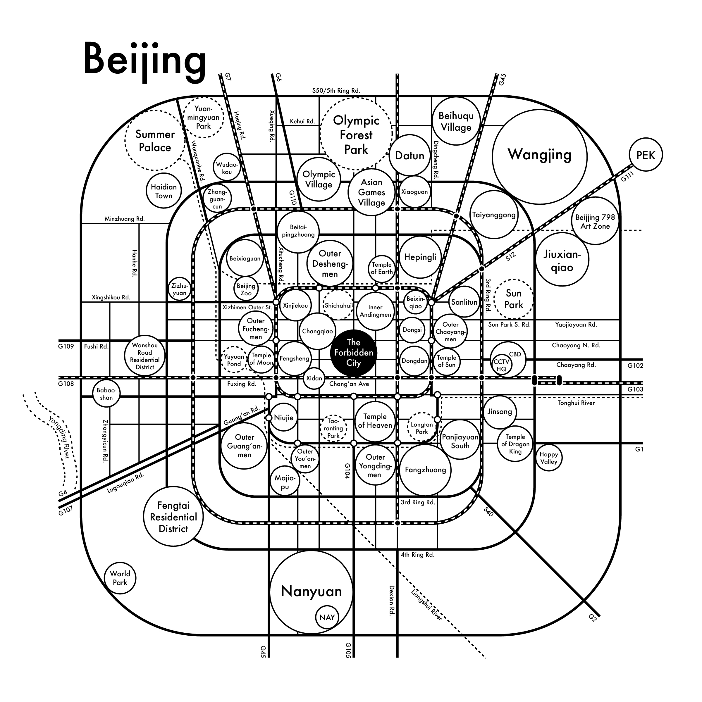
我把二环内又改回白色了但我把紫禁城做成黑色的了。你觉得如何?
我加了最重要最有影响力的地区。注意查收附件。
如果你有什么考虑和想法的话随时沟通。
祝好,
韩立
Hi Archie:
Yes. I think #5 is better than #6 since the urban design of the city of Beijing is famous for being in squares. I have checked with several of my close friends who are all originally from Beijing and all of us prefer the square design and we agree that it is more Beijing-ish.
I changed the inner area of the 2nd Ring Rd. back to white. But I made the Forbidden City in black. What do you think?
I have attached the latest file after mapping the most important and influential neighborhoods to this email. Please let me know what concerns or questions you have.
Best,
Li

May 7th, 2018, 纽约,纽约市/New York, NY
from: 阿尔奇/Archie <archie@archiespress.com>
to: 韩立/Li Han <thelostshrimpball@gmail.com>
date: Mon, May 7, 2018 at 5:56 PM
subject: 回复:关于合作项目/RE: About the Collaboration Project
嗨,韩立!
哇塞!你工作效率真是太高了!感谢!
我觉得把紫禁城做成黑色很不错。
你觉得这个地图现阶段怎么样?它很有背景的感觉吗?我可能会微调一些地方,但整体上我觉得很不错!
我打算把它发布到照片墙上。希望我明天可以发出去吧!
再次感谢,
韩立
Hi Li!
Wow you worked so quickly! Thanks so much.
I like the forbidden city in Black.
How do you feel about this? Does it “feel” like Beijing? I might nudge a few things around, but overall I think it’s pretty cool!
I’m going to show it to Instagram soon, hopefully I can get to it tomorrow!
Thanks again,
Archie
May 8th, 2018, 纽约,纽约州/New York, NY
from: 韩立/Li Han <thelostshrimpball@gmail.com>
to: 阿尔奇/Archie <archie@archiespress.com>
date: Mon, May 7, 2018 at 6:44 PM
subject: 回复:关于合作项目/Re: About the Collaboration Project
嗨,阿尔奇:
我觉得现在它看起来还挺北京的。我给我妈妈也看了。她看不懂英文但是她一眼就看出这是北京了。所以我觉得应该没什么问题。周末的时候我做了一些调整。让我再做一些润色之后明天我会尽快把 .ai文件发给你。再给我一天时间可以吗?
我还有个问题,也就是为什么我还再多需要一天。有一些名字的翻译我还是犹豫不定。你也知道中文和西文完全不一样,所以有时候会有很多翻译上的困难。不像法语或者德语,它们在语言语义上会更好应对。
那些著名的景观景点都有自己的官方翻译,比如 “紫禁城”。它是意译的不是用汉语拼音音译。但有些居民区并没有官方翻译因为他们更加随意而且是住宅区,并不具有重大意义或者很有影响力。通常在这种情况下我们就用直接用汉语拼音音译。然而这就导致了一个问题:有些具体地区的名字有含义。如果只用汉语拼音的话就体现不出来了。例如:在西北三四环中间有个地区叫 “紫竹院”。现在我用的是汉语拼音“Zizhuyuan”,但如果意译的话就会变成“Purple Bamboo Park”。它体现了我们中国人的祖先的文学底蕴—“紫” 在我们的传统中象征权贵与吉兆,在紫禁城中也同样拥有该字;“竹” 是一个喻体象征生命与健康。我个人更偏向使用 “Purple Bamboo Park”。麻烦再多给我一天时间让我和我朋友们讨论一下。我们都受过高等教育并且来自北京,中英文都很流利。我觉得等我们讨论之后用那种翻译肯定会得出个更好的结论。
你看行吗?
万分感谢,
韩立
Hi Archie:
I think this feels pretty Beijing and I showed my mom as well, who doesn't understand English at all but she was literally like, this is Beijing, right? So I guess it works. I made some slight changes on this past weekend and let me finally retouch some small things about the neighborhoods and I'll send the .ai file back to you tomorrow if that's gonna OK to give me one more day?
I do have one question, which is also the reason why I need one more day. I'm still debating on some of the translation of the names. You know that Chinese is so different from Latin languages, so there might be some difficulties on the translating part. Unlike French or German, they're relatively less problematic linguistically.
For the famous sites, they have official translations, such as "the Forbidden City." It is translated based on its meaning instead of simply using the phonetical spelling to mimic its pronunciation. But several neighborhoods don't have official translations 'cause they are more casual and residential, not that significant and influential. Usually, under this sort of circumstance, we just using its phonetical spelling instead. So here comes a potential problem: some specific neighborhoods' names have auspicious meanings. If we just use their phonetical spellings, the meaning will be loosing. For instance, there is one neighborhood named "紫竹院" in between W. 3rd and 4th Ring Roads. Right now, I'm using phonetical translation, which is "Zizhuyuan" on the map now but actually, if it's translated based on the meaning, it will go to "Purple Bamboo Park" instead. It shows the language puzzles that our ancestors play—purple is a very powerful and auspicious color in our tradition, which also appears in the authentic name of the Forbidden City in Chinese; bamboo is a metaphor that represents being strong, healthy, and safe and sound. Personally, I prefer to use "Purple Bamboo Park." So please allow me to have one more day to discuss it with my friends. We are all well-educated and originally from Beijing, speak Chinese and English fluently. So after having some "critique," I believe the names will come out in a better sense.
Please let me know what you think.
Many thanks,
Li
May 7th, 2018, 纽约,纽约市/New York, NY
from: 阿尔奇/Archie <archie@archiespress.com>
to: 韩立/Li Han <thelostshrimpball@gmail.com>
date: Mon, May 7, 2018 at 6:57 PM
subject: 回复:关于合作项目/RE: About the Collaboration Project
嗯……有点意思。
我明天也问问我工作室里的中国同事他们怎么看。他们可能也会有些想法。
Hmmm that’s very interesting.
I will ask some of my studiomates tomorrow what they think. Some are Chinese so they will probably have an opinion.
So the “big picture” has pretty much settled but there are still details to be perfected for sure.
北京城墙/Fortification of Beijing City:


北京城墙始建于明朝15世纪初并于1553年竣工。内城城墙共24千米长,15米高,墙体底部宽约20米,顶部宽约12米,拥有九座城楼。外城城墙约6至7米高,顶部约10至11米宽,顶部约11至15米宽。西部最窄,顶部只有4.5米宽,顶部7.8米宽,共有七座城楼。旧时内城外城的城楼与城墙互为一体,形成了别具一格的建筑结构。尽管现在它们已经不复存在,但它们曾经所在的地区依旧沿用了它们的名字。为了将城楼与地铁站相互区分 ,我把城楼做成了白点黑边,普通地铁站则为黑点白边。
The fortifications were built between the early 15th century to 1553 in Ming dynasty. The Inner city wall was 15 mi long and 49 ft high, with a thickness of 66 ft at ground level and 39 ft at the top, and had nine gates. The Outer city walls is 19–23 ft high, 33–36 ft wide at the top and 36–49 ft wide at the base. The western sections were the narrowest, averaging only 14.8 ft at the top and 25.6 ft at the base and had seven gates. The gates used to be appearing on the Inner and Outer city’s walls are a very cool feature. Even though they are not there any longer, those areas are still named after them. In order to differentiate them from subways transfer stops, I made the gates in white circles with black stroke and normal stops in black circles with white stroke.
May 8th, 2018, 纽约,纽约市/New York, NY
from: 韩立/Li Han <thelostshrimpball@gmail.com>
to: 阿尔奇/Archie <archie@archiespress.com>
date: Tue, May 8, 2018 at 11:33 AM
subject: 回复:关于合作项目/Re: About the Collaboration Project
嘿,阿尔奇:
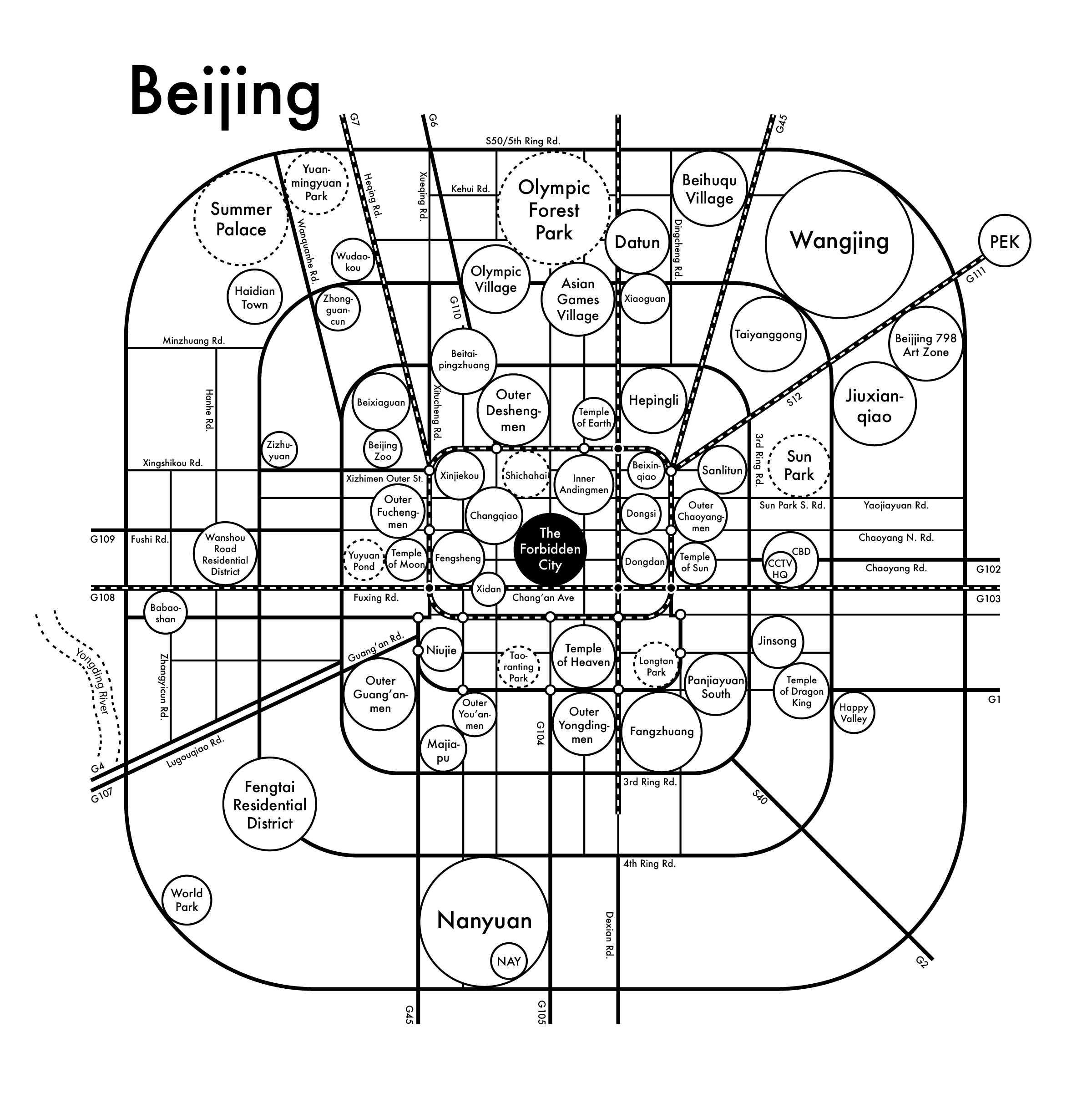
我刚刚完成了一些修改。我昨天晚上和我的三位朋友一起讨论到底该用哪种翻译一只讨论到夜里两点并且今天早晨我们又讨论了一会儿。最终我们决定两者都用但是具体要具体情况具体分析。
在皇帝们在位的时候,北京市的面积大概就是二环路的范围,分为内城、外城、皇城和禁城。在那个时期,北京市的城市规划非常严格地遵循风水学。所以在二环路以内的命名我们决定采用意译而非音译。你可以从地图上看到天坛、地坛、日坛和月坛的翻译都用的是意译法。就城楼来说,我们决定采用音译而非意译。首先,这是更通俗的表达方式;其次,如果强行翻译的话在英文里并不是很说得通,与此同时那些吉祥的寓意还会流失。例如:在北二环上有 “安定门”。“门” 意指 “城楼、城门” 而 “安定” 是一个真实存在的词,寓意 “平静;正常;稳定”。但是……如果强行翻译为 “稳定的门”……我觉得……还是算了……在英语里太奇怪了……对于二环外的城区来说,它们的历史相对更短,对于命名和风水等的规范也相对更松。所以我们一致同意用汉语拼音作为翻译。因此我把 “北新桥梁” 改回了 “北新桥”。
我把最新的文件附在这封邮件了。注意查收。
万分感谢,
韩立
Hey Archie:
I just finished revising it on my side. So I was having this conversation debating which translation system to use with 3 other friends last night till 2 and we continued discussed a little this morning. And we decided to apply both but case by case.
During the time the emporers used to rule China, the city of Beijing was pretty much sticking to 2nd Ring Rd—Inner City, Outer City, Imperial City, and Forbidden City. During then, there were very strict urban design rules based on Fengshui. So we decided to use the translating based on their meanings instead of pronunciation for the sites within 2nd Ring Rd. You can see that there are Temple of Heaven, Earth, Sun, and Moon. As for fortifications, we decided to leave them using pronunciations instead of meanings. First, this is more of a common way. Also, they're too hard to translate and they don't make that much sense in English but lose its Chinese auspices. For instance: there is Andingmen on N. 2nd Ring Road, whose “men” part means “gate” and the rest—"Anding" is a real word meaning stable, settled, peaceful, and safe and sound. But... Stable Gate?! I'm like... Nah... That is super awkward... For the areas outside 2nd Ring Rd, they are relatively new and the rules are a little less strict. And we agreed on using pronunciations. So I changed "Beixin Bridge" back to "Beixinqiao" etc.
I attached the latest file to this email and hope it finds you well.
Many thanks,
Li
May 8th, 2018, 纽约,纽约市/New York, NY
from: 阿尔奇/Archie <archie@archiespress.com>
to: 韩立/Li Han <thelostshrimpball@gmail.com>
date: Tue, May 8, 2018 at 11:48 AM
subject: 回复:关于合作项目/RE: About the Collaboration Project
嗨,韩立!
感觉效果太棒了。
感谢你花了这么多时间和精力在地图设计上。很有可能它会成为最好的地图设计。
我打算把你网站上的设计过程邮件日记给我办公室的朋友看你觉得可以吗?我们有个Slack频道。我打算给20个人看的样子。
我还有一些问题:
那些在高速公路交叉口的白点是什么?它们一定非要在那儿吗?
在城市的西南部和东南部真的没有什么东西吗?尤其是四五环之间?
三环路我有点没看明白。到底那条是?虚线还是实线?既然虚线和实线之间并没有太多内容,我觉得我们可以就简化成一条线。我理解这么做可能并不精确,但是别忘了我们做这个地图的目的并不是为了要把每一个细节都记录下来。这是一个大感觉的地图,不是精确的地图。最重要的就是要让环路系统让人在第一时间第一感觉上抓住。现在看起来这种感觉有点儿丢失了。
还有别的一些细节我觉得没必要加上。比如:103国道和108国道的拐点完全没必要。可以用一条线概括。
每条路都需要有名字标注。我觉得我们可以移除五条路。现在细碎的路太多了。我有点眩晕了。现在地图上的信息太多了导致我并不想去读取了。
那些河很重要吗?我觉得有点太多了而且它们会令人分散注意力。我把河流的图层隐藏后感觉就好多了。但如果它们很重要的话我们可以保留。
你有时间再做一下微调吗?如果没有的话我自己也能做。希望我不会毁了整幅地图吧!
谢谢你,韩立!
阿尔奇
Hi Li!
That looks amazing.
Thanks so much for taking such careful time and attention to making this the best possible map.
Is it OK if I share that diary with my office friends? We have a Slack channel and I was going to post it for about 20 people.
I have some questions:
What are all the little white dots at the intersection of the highways? Are they necessary?
Is there really nothing in the SW and SE of the city? Between 4th and 5th Ring Roads?
The third ring road is confusing me a little bit. Which one is it? The dotted line or the solid line? Since there is not much between the dotted and solid lines, I think we can simplify it to one line. I know that probably isn’t totally accurate, but remember the point of this map is not to keep track of so many little details like that. It’s a “big picture” map, not a details map. The biggest picture is make sure the ring system makes sense quickly and intuitively, but right now I think it’s a little lost.
There are also some details on here that I think are unnecessary. For instance, the G103/G108 interchange is totally unnecessary. That can just be one line.
Every road needs a name. I think we can remove about 5 roads on this. It’s too many right now. I’m getting what is called the “dazzle effect”, there is so much information that I give up trying to read it.
Are the rivers very important? I think there are too many and they are a little distracting. I turned off that layer and I think it feels better, but if they are necessary we can get rid of them.
Let me know if you have time to do a little tweaking, otherwise I can do it myself before I share it around, but hopefully I don’t ruin the map!
Thanks Li!
Archie
的确,地图的设计现在看起来有些眼花缭乱。在新一轮 “接力赛” 之后,我去掉了地铁10号线和河流并且把1号线和八通线连成一条线了。在城楼的去留上依旧拿捏不定。同时也在等阿尔奇做了减法之后把路名都加上。
It is true that so far, the map looks overwhelming. After this new round of “tennis playing,” I removed subway 10 train, rivers, and connected 1 train and Batong train together. Still debating on the fortification gates and waiting for naming the roads after Archie’s “minus game.”
May 8th, 2018, 纽约,纽约州/New York, NY
from: 韩立/Li Han <thelostshrimpball@gmail.com>
to: 阿尔奇/Archie <archie@archiespress.com>
date: Tue, May 8, 2018 at 12:41 AM
subject: 回复:关于合作项目/Re: About the Collaboration Project
嗨,阿尔奇:
完全没问题!
实线是三环路,虚线是北京地铁10号线。我把10号线移去了、去掉了103国道和108国道的拐点并且删掉了河流的图层。
那些白点是老北京城墙上的城楼。它们非常有名而且很多地区和道路都是以它们命名的。我认为它们鉴证了北京城的历史,同时也是它们使得北京与众不同且难忘。大多数城楼都已经被拆除了但是还是有很多地铁站建在同一地点并使用相同的名字。但关于它们的去留还可以继续商榷。
是的。在南二环外就基本上没有什么了。在北五环外还有很多建设但是南城就完全是另一幅光景了。北京的城市规划并不总是均衡的。
关于道路,我也觉得现在确实有太多条路了。你可以把你觉得没必要的路删掉然后我把还保留着的所有道路都标上名字?确实每条路都有自己的名字。但北京市的道路命名系统和纽约市的不太一样。通常在纽约一条连续的路就只有一个名字。但是在北京,尽管它们还是同一条路,在不同路段也会有不同的名字而且把它们翻译成汉语拼音之后有些会变得非常长。要不这样,你先做些减法之后我把剩下的内容都标上名字之后我们在讨论?
附件是最新的文件。你可以把你觉得没必要的路都删掉。你不会把地图毁了的。
祝好,
韩立
Hi Archie:
No problem! Go for it!
The 3rd Ring Rd. is the solid line and the dashed line is Beijing Subway 10 train. I removed the dotted line. I simplified the "G103/G108" interchange and I deleted the river layer.
The white dots are the gates of the fortification of the city. They are very famous and there are a lot of neighborhoods and roads naming after them. I think they mark the city's history and they also made Beijing so special and memorable. Most of them are torn down for decades but there are still subway train stops at the same spots and sharing the same names. But this is a debatable element whether to keep them or delete.
And yes. It's true. There's literally nothing much southern than S. 2nd Ring Rd. There is still something outside N. S50/5th Ring Rd. but the south is a whole different story. The urban design is pretty uneven.
So for the roads, I do agree that I put too many of them on the map. You can remove the ones you think unnecessary and then I'll put names next to the ones we still have? It's true that every road has name(s). But It's a little different from the system we have here in NYC. Usually, one continuous road using only one name. But in Beijing, even though they are still the same road, but it has different names in every single block and some of the spelling can be very long after translation. So let's say, you can do some minus first and then I'll try to name the rest and then let's discuss it later?
I just attached a new file to this email. And feel free to delete the roads you think unnecessary. There won't be any chance you could ruin it.
Best,
Li

May 8th, 2018, 纽约,纽约州/New York, NY
from: 阿尔奇/Archie <archie@archiespress.com>
to: 韩立/Li Han <thelostshrimpball@gmail.com>
date: Tue, May 8, 2018 at 3:39 PM
subject: 回复:关于合作项目/RE: About the Collaboration Project
嗨,韩立!
附件是我最新改过的结果。
我可得我们现在失去了你之前提到过的二环路的形状。我已经看不到那个特殊的形状了因为在二环路周围和二环内有太多内容了,尤其是在交叉路口的那些小圆圈,因为他们并没有被标上名字。我觉得我们应该去掉它们。我理解他们在文化角度上十分重要,但我对它们在地图上是否被表达出来了存疑。它们在北京真的具有导航作用吗?所以,保留二环路还是城楼二选一。
我把中心城区的道路网删了因为没有名字的话它们很令人摸不到头脑。他们并没有起到任何帮助。这是我在处理 “市中心” 时的惯用伎俩。
我们能把永定河也删了吗?感觉它就像是被随便放上去的。
下面这几条是针对北京地图的几点规范,也同样适用于我们未来合作的所有地图:
道路:每一条路都至少要有一个名字。如果只有路没有名字的话没有任何意义。房地产太值钱了!
我喜欢把路名标记在路上方这样路看起来就像下划线一样。
我非常讨厌太多圆圈挤在一起,我幽闭恐惧症都犯了。给它们一些呼吸的空间。
我们马上就要完成了!但我觉得那些城门让我很不爽。
这是一个很好的地图设计。它表现出了环路系统的感觉,但如果你更深入地观察,这个系统又瓦解了,有很多例外凌驾于系统之上。或许这就是中国的一派作风?我不知道。但我觉得我们肯定有更诗意的表达方式。
有什么想法随时沟通。等你说没问题了以后我就会发布到网上去。
阿尔奇
Hi Li,
Here are my edits.
I think we are losing the shape of the 2nd Ring Rd. that you mentioned before. I can’t see that special shape that resembles the character because there is so much going on around/inside of the 2nd Ring Rd., especially with the little circles at the intersections. Because none of those are actually labelled, I think we should get rid of them. I understand that they are culturally very significant, but I’m just not sure if they are translating here without labels. Do they really help orient you in the city? So, pick that 2nd Ring Rd. shape or pick the gates.
I removed the grid in the center city because it was confusing, and with nothing labelled, those roads aren’t helpful. This is a pretty normal tactic for me in “downtown” situations.
Can we get rid of the Yongding River? It looks like an afterthought.
Here are things that apply to this map, and should be noted for future maps:
The roads: Everything needs at least one name. It’s pointless to have a road without a name on here. Our real estate is too valuable!
I like when the road name is on top of the road so it acts as like an “underline”.
I don’t love when too many circles are squeezed into one space, it feels claustrophobic. Give them a little breathing space.
We’re very close! I think the gates are throwing me off.
This is a good map. It presents an illusion of structure with the ring roads, but when you get deeper into looking at it, the system breaks down, and there are many exceptions to the rules. Maybe like China? I don’t know. I’m sure there’s a nice poetic comparison we can come up with.
Let me know what you think. I still haven’t posted it but will if you say this looks OK.
Archie

基于阿尔奇的反馈,我把每个地区的圆圈都缩小了一点并且移除一些冗余的部分。鉴于在二环内没有道路网格系统了,我把各个地区的位置又进行了微调并尝试了用椭圆形来做 “什刹海”。
Based on Archie’s critique, I made every circle of the neighborhoods smaller and removed some redundancy. Since there’s no grid system inside 2nd Ring Rd., I rearranged the neighborhoods a little and tried ellipse to represent “Shichahai.”
May 9th, 2018, 纽约,纽约州/New York, NY
from: 韩立/Li Han <thelostshrimpball@gmail.com>
to: 阿尔奇/Archie <archie@archiespress.com>
date: Wed, May 9, 2018 at 11:35 AM
subject: 回复:关于合作项目/Re: About the Collaboration Project
嗨,阿尔奇:
按照我们讨论过的我又做了些润色。
在地区上,我把每一个圆圈都进行了调整营造了更多呼吸的空间。和之前相比我觉得现在看起来更舒服了。
对于道路网,我移除了一些路然后把剩下的每一条都标上名字了。希望我都没有落下什么。我也觉得把二环内的路去掉以后看起来好多了。我把二环内的地区位置也微调了一下。但是我想保留的是正中间那条路。在城市规划和历史上这条 “中轴路” 都很重要。二环内的规划是左右均衡的,几乎呈对称。(这条路并不真叫中轴路。他的每一段都有一个独立的名字。但是北京人依旧习惯性叫它 “中轴路” 因为它确实就是城市规划的对称轴。)例如:西有 “西单” 东有东单。它们以中轴路为对称轴分布在左右两侧。所以我个人认为在二环内保留中轴路很合理。除此以外,你觉得道路网还乱吗?如果你还觉得乱的话,我可以再删掉几条路。
在新的文件里有两张画板。唯一的区别就是二环内靠近紫禁城北部的什刹海。一个是椭圆形一个是圆形。你觉得用哪个方案继续往下做比较好?期待你的回复。
万分感谢,
韩立
Hi Archie:
I made some more retouching as we discussed.
For the neighborhoods, I rearranged every single one of them to make more breathing spaces. I think it's less intense now comparing with the former approach.
For the grid system, I removed several streets and I labeled every one of them. Hope I didn't miss one. I agree that removing the ones within 2nd Ring Rd. makes the map so much cleaner. You can see that I changed the neighborhoods in it a little bit. But the only one I prefer to keep is the vertical one right in the middle. It is very important in the design and the history since it is the "axis road" and the urban design within 2nd Ring Rd. is symmetrical, almost symmetric. (There's no official name of axis road in the urban design. The road in each block has separate names. But Beijing residents still call it "axis road" epidemically since it is literally the axis of the city.) For instance, you can see there's "Xidan" on the left and "Dongdan" on the right. "Xi" means west and “Dong” means East and they are symmetrically sitting on the opposite sides. So personally, I think keeping the axis road as the only one inside 2nd Ring Rd.is reasonable. Besides, do you think the grid system is still too much? If so, I can keep removing a few.
There are two artboards in the new file. The only difference is the water area—Shichahai, which is at the top part of 2nd Ring Rd. close to the Forbidden City. One is elliptical and the other one is a circle. Which one do you prefer to move forward? Looking forward to hearing from you.
Many thanks,
Li

May 9th, 2018, 纽约,纽约市/New York, NY
from: 阿尔奇/Archie <archie@archiespress.com>
to: 韩立/Li Han <thelostshrimpball@gmail.com>
date: Wed, May 9, 2018 at 3:47 PM
subject: 回复:关于合作项目/RE: About the Collaboration Project
嘿,韩立!
太棒了,这些想法都很棒。
你能把所有的地铁线也都标上名字吗?它们在地图上占了很大比重但是没有详细信息。
我希望所有的名字都可以左对齐或者右对齐。我不喜欢中心对齐。
我把国道超出五环的部分都删掉了。我理解为什么他们会继续向外走,但是我们更关注的是五环内而不是五环外。我觉得这样看起来更好一些。
这个地图设计看起来非常好!
太感谢你了,韩立!
阿尔奇
Hey Li!
Awesome, those are great thoughts.
Can you name all the subway lines? That are making a huge statement on this map, but there is not explanation.
I also like to keep the names justified to the left or the right instead of in the middle of the road.
I pulled the G roads inside. I understand they continue out, but we’re really concerned with the area inside Beijing and not outside. I think it looks nicer.
This looks so good!
Thanks so much Li!
Archie

May 9th, 2018, 纽约,纽约州/New York, NY
from: 韩立/Li Han <thelostshrimpball@gmail.com>
to: 阿尔奇/Archie <archie@archiespress.com>
date: Wed, May 9, 2018 at 11:35 AM
subject: 回复:关于合作项目/Re: About the Collaboration Project
嘿,阿尔奇:
我把 “S50/五环路” 移到地铁线路的图层里了使它可以把斜的那些地铁线路终点挡住。这样会让整个地图看起来更齐整。
我把所有的地铁线都标上名字了:1号线、2号线、5号线、13号线、八通线和机场快轨。我删掉了 “111国道” 然后把 “S12” 移回原来的位置了。在标记了机场快轨之后,这条路上已经有三个不同的名字了。严格来说,S12是机场高速并且它是111国道的一部分。所以我觉得保留S12删掉G111似乎更合理而且它们能够形成互补。
我把所有道路的名字都推到角上去了。唯一一个居中对齐的就是地图正中央紫禁城下面的 “长安街”。它在城市的正中间,跨越了中轴路,而且是对称的。所以你介意它作为唯一一个例外吗?
祝好,
韩立
Hey Archie:
I moved "S50/5th Ring Rd." into the subway trains layer to make it covering the diagonal ends of the brushstrokes of the trains to make it look cleaner on the edge.
I have labeled all the subways trains: Line 1, 2, 5, 13, Batong Line, and Airport Express. I deleted "G111" and moved "S12" to its former place. After labeling Airport Express, there are 3 names on the same road. Technically speaking, S12 stands for airport expressway and it is part of G111. So I think with the labeling of the subway, keeping S12 and deleting G111 makes more sense and they are paralleling each other.
I pushed all the roads' names to the corners. The only one remaining center aligned is "Chang'an Ave" at the center of the map right below "the Forbidden City." It is at the center of the city, across the axis road, and symmetric. So do you mind keeping it as the only exception there?
All the best,
Li
May 11th, 2018, 纽约,纽约州/New York, NY
from: 阿尔奇/Archie <archie@archiespress.com>
to: 韩立/Li Han <thelostshrimpball@gmail.com>
date: Fri, May 11, 2018 at 11:45 AM
subject: 回复:关于合作项目/RE: About the Collaboration Project
你可以把Beijing也写上中文吗?我想看看加上之后的效果。
谢谢!
阿尔奇
Could you also write Beijing in Chinese characters? I want to see how it looks as a subheading.
Thanks!
Archie
May 9th, 2018, 纽约,纽约州/New York, NY
from: 韩立/Li Han <thelostshrimpball@gmail.com>
to: 阿尔奇/Archie <archie@archiespress.com>
date: Wed, May 9, 2018 at 11:35 AM
subject: 回复:关于合作项目/Re: About the Collaboration Project
嗨,阿尔奇:
我把中文加在 “Beijing” 旁边了。注意查收附件。
祝好,
韩立
Hi Archie:
I added the Chinese characters right next to "Beijing." I attached the file to this email.
Best,
Li
May 11th, 2018, 纽约,纽约州/New York, NY
from: 阿尔奇/Archie <archie@archiespress.com>
to: 韩立/Li Han <thelostshrimpball@gmail.com>
date: Fri, May 11, 2018 at 2:59 PM
subject: 回复:关于合作项目/RE: About the Collaboration Project
嗨,韩立!
我喜欢加上中文的效果,但是我觉得它和别的地图差距太大了而且别的地图没有带中文的。所以就还是只保留Beijing吧。
你觉得现阶段看起来完成了吗?我觉得你简化地非常完美。感觉可以压印了!!
你觉得呢?还有什么要补充的吗?
耶!
阿尔奇
Hi Li!
I like it, but I think it is too divergent from the other maps and there aren’t any other characters on here, so let’s just use Beijing.
Does this look finished? I think the cleaning up you did looks perfect. Seems ready to print!!
What do you think? Anything else?
Yay!
Archie
May 11th, 2018, 纽约,纽约州/New York, NY
from: 阿尔奇/Archie <archie@archiespress.com>
to: 韩立/Li Han <thelostshrimpball@gmail.com>
date: Fri, May 11, 2018 at 3:40 PM
subject: 回复:关于合作项目/RE: About the Collaboration Project
嗨,阿尔奇:
是的!我觉得离最终压印出来已经非常近了。但在压印之前,让我再最后检查一下所有的拼写把所有的错字都改过来。我会在这周末结束前把文件发给你。
我还有个问题。我们要手动再调整一下字偶间距和行间距吗?比如地图左上角 “圆明园(英文)” 的行间距因为上部和下部看起来有些不均衡。我可以调整一下让它视觉上更匀称。你觉得这有必要吗?还是你想维持现状?
祝好,
韩立
Hi Archie:
Yes! I think it's super close to being finally printed out. But before that, let me do some final check-ups with every word to kill any possible typos and get the file back to you by the end of this weekend.
Also, I got a question. Do we need to manually kern and adjust a bit on some of the leadings? For instance, the leading of "Yuanmingyuan Park" at top left corner seems a little uneven because of the ascenders and descenders. I can make it more optically symmetrical. Do you think it necessary? Or you prefer to leave it that way? Please let me know.
Best,
Li
May 11th, 2018, 纽约,纽约州/New York, NY
from: 阿尔奇/Archie <archie@archiespress.com>
to: 韩立/Li Han <thelostshrimpball@gmail.com>
date: Fri, May 11, 2018 at 3:46 PM
subject: 回复:关于合作项目/RE: About the Collaboration Project
嗨,韩立!
是的手动调整一下字偶间距!虽然它很烦人但是很值得!
谢谢你这么花时间精力地做设计!我已经迫不及待要开始上海思维导图设计了!
对了!你想不想下周一起喝个咖啡或者什么的?我在下东区工作。你在哪活动?
开心,
阿尔奇
Hi Li!
Yes do a little bit of manual kerning! It’s so annoying but so worth it!!
Thank you for all the hard work! I’m so excited to get started on Shanghai!
And: Do you want to get coffee or something next week? I work in the Lower East Side. Where are you?
Cheers,
Archie
May 13th, 2018, 纽约,纽约州/New York, NY
from: 阿尔奇/Archie <archie@archiespress.com>
to: 韩立/Li Han <thelostshrimpball@gmail.com>
date: Sun, May 13, 2018 at 11:45 AM
subject: 回复:关于合作项目/RE: About the Collaboration Project
嘿,阿尔奇:
注意查收附件。我手动调整了一些字偶间距和行间距。我也检查过所有的拼写了。我觉得现在可以压印了。如果你发现还有什么需要调整的随时告诉我。
耶~~~~~~~~~~~~~
韩立
Hey Archie:
Please find the attached file. I manually kerned and adjusted several leadings. And I also have gone through all of the spellings. I think it's ready for print now. Feel free to let me know if you find anything which needs to be revised further.
Yayyyyyyyyyyyyyy,
Li

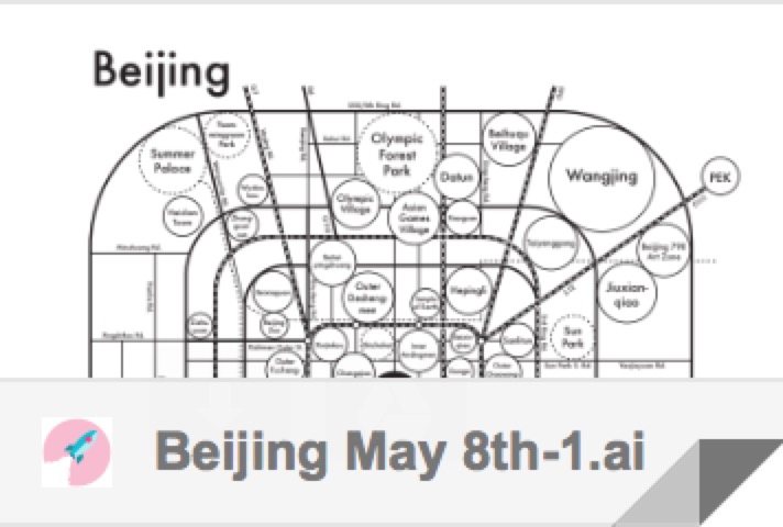
这是阿尔奇凸版印刷工作室简报上关于这一项目的文章。“北京思维导图” 可以在阿尔奇压印—北京地图页面购买,凸版印刷成品尺寸为20 x 20 cm。感谢您耐心阅读。希望这个项目可以对您在极简主义、地图设计和信息可视化相关项目上有所启发。
Here’s a little press of Archies’ Press’s newsletter on this project. And the “Beijing Mind Map” is available at Archie’s Press Beijing Map in letterpress in 8 x 8 inches. Thanks for reading and I hope this project could be inspiring on minimalism, mapping, and envisioning information related projects.
#合作项目/collaborative project
#信息可视化/envisioning information
#思维导图设计/mind map design
#平面设计/graphic design
#凸版印刷/letterpress